

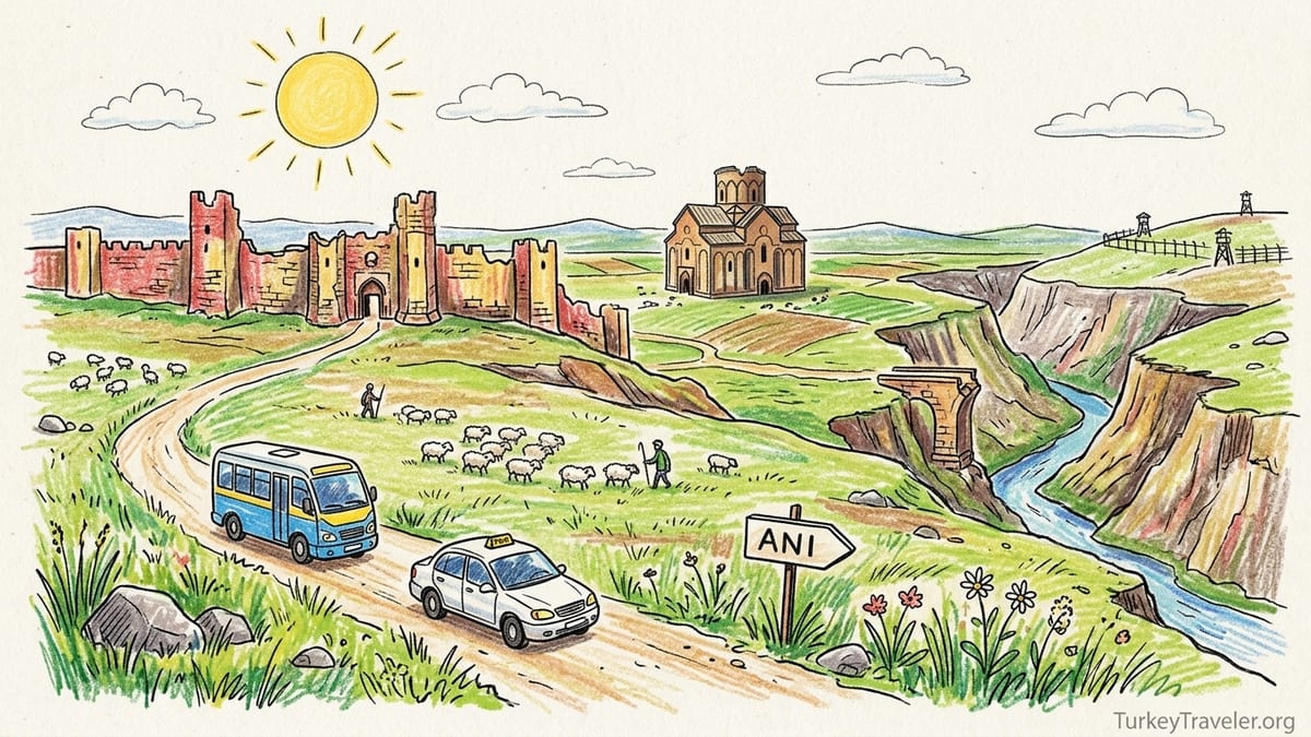
From Kars, the road to Ani pulls you steadily east, lifting you onto a wide, wind-brushed plateau that feels more like an idea of a frontier than a place on a map. I had seen photographs of the medieval Armenian city before I arrived in eastern Türkiye, yet nothing quite prepared me for that 42 kilometre journey from town streets to open steppe, from the clutter of everyday life to a landscape where history lies almost entirely exposed to sky and weather.
The Road From Kars to the Edge of the Plateau
I left Kars just after the morning rush, when the minibuses were still filling at the small informal stand near the city centre. In 2024, a municipal-style minibus was still the main budget way to reach Ani, leaving around 9:00 in the morning and returning just after midday, while local drivers clustered nearby offering private round-trips that hovered in the range of 1200 to 1500 lira for half a day, depending on your bargaining skills and fuel prices. I had arranged a shared taxi through my guesthouse the night before, agreeing that the driver would wait three hours at the site and then bring me back to Kars.
Almost as soon as we left the outskirts, apartment blocks gave way to low stone houses and then to the bare, high Anatolian plateau. The road climbed gently, cutting across a treeless expanse of pale grasses and dark soil scarred by long winter frosts. To the south, distant hills were still patched with snow even in late spring. Occasional herds of sheep and cows moved like smudges of charcoal across the land, watched by solitary shepherds wrapped against the wind.
There is little shade on this route. Even inside the car I felt how exposed the land was, with gusts rocking the vehicle and dust lifting from the verges. The sense of approaching a border was subtle at first: a checkpoint cabin here, a low line of fencing there, army posts set back from the road. My driver pointed east with a brief nod and said, simply, “Armenistan,” reminding me that this everyday road for him runs almost exactly parallel to a closed international frontier.
After roughly 40 minutes, the first outline of Ani appeared not as a single ruin, but as a ragged line of fortifications along a distant ridge. The famous city walls were just visible against the bright sky, broken towers rising above the plateau like worn teeth. Only as we drew closer did the deep ravines that protect the site begin to reveal themselves, cutting the land into sheer-sided canyons that plunge down to the Arpaçay (or Akhurian) River, which today marks the Türkiye–Armenia border.
First Glimpse of Ani: Walls, Ravines and an Empty Horizon
The parking area outside the archaeological site is plain: a small ticket building, a café and souvenir stall, toilets housed in utilitarian blocks, a scattering of tour buses and a few taxis waiting for their passengers. This simplicity is part of Ani’s character. There are no theatrical entrance avenues or elaborate visitor centres here, just a modest gate in a low fence and the long curve of the medieval walls beyond, still impressive after a thousand turbulent years.
At the ticket window, I paid the modest entrance fee quoted for 2024, a sum comparable to other secondary archaeological sites in Türkiye and less than that of headline attractions such as Ephesus or Topkapı Palace. Exact prices shift with inflation, so it is worth checking the official museum portals in advance, but Ani remained one of the more affordable UNESCO World Heritage Sites in the country. Opening hours followed the standard seasonal pattern, roughly from mid-morning to late afternoon in winter and extended into the early evening in summer, though visitors were encouraged to arrive well before the final admission to avoid walking out across the plateau at dusk.
Inside the entrance, the first view of Ani stopped me in my tracks. From the path just beyond the modern gate, the land suddenly fell away, revealing the main ravine of the Arpaçay River and, beyond the canyon, the rolling territory of Armenia. Guard posts sat on both sides, evidence of the long-closed border that has shaped Ani’s recent life as much as any archaeological policy. It is a peculiar sensation to stand in a place founded as a crossroads of trade and pilgrimage, now fixed beside an international frontier with no crossing at all. You can look into Armenia from Ani, but you cannot walk there.
Turning from the ravine back toward the city, the fortifications stretch across a shallow arc, walls that once ran for several kilometres enclosing a dense urban environment. Even in partial ruin, they retain scale and rhythm. The towers are alternately round and square, patched in later centuries, some decorated with lions or inscriptions. I passed under the Lion Gate, one of the main entrances, and felt, with each step, the difference between visiting a ruin and entering a city that has simply lost almost all its inhabitants.
A Medieval Armenian Capital on the Silk Roads
To understand the feeling of walking through Ani today, it helps to remember what it once was. In the tenth and eleventh centuries, Ani was the capital of the Armenian Bagratid kingdom, home to tens of thousands of people and a flourishing centre of commerce and culture. Its position on this plateau was not accidental. The city dominated routes that linked Anatolia with the Caucasus, connecting Byzantium and the Black Sea to Persia, Syria and Central Asia. Caravans once threaded through its gates bringing silk, spices, metalwork and precious manuscripts.
Under the Bagratid rulers, particularly King Smbat II and his successors, Ani’s urban fabric grew outward from earlier fortifications into a dense mosaic of churches, palaces, markets and defensive works. Armenian master builders developed a distinctive architectural vocabulary here, using finely cut volcanic tuff in alternating bands of colour and experimenting with domes, pointed arches and tall, slender drums that would influence church construction across medieval Armenia. The city gained poetic titles such as “City of 1001 Churches” and “City of 40 Gates,” a reflection less of literal counts and more of its reputation as a place of spiritual and civic abundance.
Ani’s history did not stop with the Bagratids. Over the following centuries it passed under Byzantine, Seljuk, Georgian and other authorities, each leaving their imprint. Byzantine rule in the mid-eleventh century folded the city into the empire’s frontier defenses. Seljuk control brought new mosques, caravanserais and an Islamic intellectual life into what had been a predominantly Christian urban landscape. Later Georgian influence saw renewed patronage of Armenian monasteries in the region, including the important Horomos complex to the northeast. Trade ebbed and flowed with shifting political tides, so that Ani’s fortunes rose and fell over multiple generations, not because of a single catastrophe but due to the slow redirection of routes, changing regional power and ecological pressures.
Standing inside the walls today, you feel this layered history not as a tidy sequence but as overlapping presences. Churches from different centuries lean into each other across open fields. The lone minaret of a mosque stands near the outlines of what may have been a bazaar or palace. A stone bridge that once spanned the border river survives only as a solitary pier and abutment. The city did suffer invasions and earthquakes, but its decline was also the story of shifting trade, new political centres and a gradual emptying out of population, until wind and grass claimed what the economy no longer needed.
Walking the City: From Lion Gate to Ani Cathedral
Ani rewards walking more than almost any site I have visited in Türkiye. Unlike Ephesus, where monumental buildings line a compact tourist circuit along Curetes Street and the Marble Road, Ani spreads its surviving structures across roughly 78 hectares of open plateau. The full loop that most visitors manage inside three or four hours covers about 4 to 5 kilometres on foot, with gentle slopes punctuated by occasional steep descents and climbs to viewpoints and the citadel. Under a high sun and constant wind, those distances feel longer than they look on a map.
From the Lion Gate, I followed the main dirt track that once formed the city’s principal axis. Almost immediately the bulk of Ani Cathedral came into view on my right, rising from a slight hollow in the ground. Its dark red and black stone glowed softly under a hazy sky, the drum and dome that once crowned it long gone, yet the proportions still perfectly legible. Before visiting the interior, I stood back to take in its setting: not squeezed among other buildings, but isolated, with broad grass all around, as if the surrounding quarters had been carefully erased.
Approaching the cathedral, I became more aware of the masonry that defines Armenian architecture here. The walls rest on a strong stone socle, rising in carefully laid courses of volcanic tuff. Many of the blocks bear masons’ marks, and the corners are stiffened by engaged pilasters that rise into blind arcades. These arcades, a hallmark of Armenian design, give the facades a vertical rhythm without relying on sculpture overloaded with detail. On the western and southern sides, slender columns support pointed arches, forming shallow niches that catch the light and break the wall surface into panels.
Inside, the cathedral is roofless but not empty. Tall piers rise like tree trunks, their capitals simple yet elegantly profiled. The ground is bare earth and fragments of stone, yet in the play of openings and supports you can still read the building as a sophisticated domed basilica. Historians see in it the hand of the architect Trdat, who also supervised repairs to the dome of Hagia Sophia in Constantinople, and walking among the shadows of his work at Ani you sense why. The building is both massive and remarkably light, its load-bearing walls punctuated by windows that would once have filtered coloured light onto mosaics and painted surfaces.
Across the Plateau: Holy Redeemer and St Gregory of Tigran Honents
From the cathedral I continued east along the track, the wind picking up and the plateau landscape widening around me. To my left, toward the city’s northern edge, the land rolled gently upward toward the citadel hill. To my right, the ground tilted gradually down toward the ravine, where the river flashed like a strip of metal between plunging cliffs. Ani’s monuments appeared not in neat sequence but almost by surprise. The half-ruined Church of the Redeemer, for example, emerges only as you draw quite close, a cylindrical mass cleft almost exactly in half.
The Church of the Redeemer was once one of Ani’s most sophisticated domed churches, built in the early eleventh century to house a relic of the True Cross. Today, only one semicircular half of the structure survives, its other half lost to time, weather and structural weakness. Standing before it is like looking at a vertical cross-section through medieval Armenian architecture. You can see the interior arcade of blind arches, the traces of a drum, the carefully cut stone ribs. It is a powerful reminder that these buildings are not mere shells but three-dimensional compositions assembled with both engineering and theology in mind.
Continuing toward the edge of the plateau, the path curved toward the Church of St Gregory of Tigran Honents, perhaps the best preserved of Ani’s major churches. From a distance its tall, narrow silhouette resembles other Armenian churches in the region: a rectangular body supporting a cylindrical drum and conical roof, with a finely ornamented apse projecting eastward. As I approached, the quality of the stonework became clear. The exterior walls display the classic Armenian use of alternating red and darker basalt-like tones, enlivened with blind arcades and carved crosses. Inscriptions in Armenian script run along bands near roof level, quietly asserting patronage and faith across nearly nine centuries.
Inside St Gregory of Tigran Honents, I found what many visitors rank as Ani’s most moving surprise: surviving frescoes that still cling to the walls and vaults. Not every painting is intact, and conservation areas are clearly marked, but enough remain to convey a vivid sense of medieval devotional art. Scenes from the life of Christ and stories of Armenian saints unfold in panels framed by painted architectural motifs. The colours are subdued but recognisable: deep blues, earthy reds, touches of white and gold. Unlike the mosaic brilliance of Cappadocian cave churches or the polished grandeur of Renaissance fresco cycles, these images feel intimate, almost fragile, as if painted for a congregation that still might step in from the plateau at any moment.
Citadel Heights, Holy Apostles and the Edge of the Border Canyon
From St Gregory’s church it is tempting to keep following the cliff-side path, but I turned inland, skirting back toward the central plateau to save the river views for later. The remains of the Church of the Holy Apostles lie in this inner zone, less dramatically perched than some of the other monuments yet crucial for understanding Ani’s religious topography. Today, the Holy Apostles is a low, tumbled ruin, its plan only partly legible in foundation walls and scattered carved stones. Walking among them, you notice more clearly the diversity of Armenian masonry: corner blocks with finely tooled edges, fragments of column drums, bits of carved cornice that once framed windows or doors.
From here I climbed toward the citadel hill, the highest point within the city. The path is steep in places and exposed to the wind, but the ascent is rewarding. From the top, the full extent of the medieval urban area comes into view, outlined by the line of walls and the sudden void of the ravines. It is here, more than anywhere else, that Ani feels like an abandoned city rather than a scattered ruin. You can imagine streets and quarters where now there is only grass, see how the cathedral, major churches and possible palace complexes relate to one another. To the east, the Arpaçay canyon cuts like a deep scar, with modern Armenian villages visible on the opposite bank.
Descending toward the river, the mood shifts again. Paths branch out toward cliff-edge viewpoints from which you can look down on the solitary pier of the old bridge that once connected Ani with lands now inside Armenia. A fragment of arch clings to the bank, while on the opposite side the ghost of an approach road is still visible in the rock. Border fences and watchtowers are reminders not to stray from marked routes. Photography is permitted within the archaeological zone, but visitors are expected to respect any signs indicating restricted areas along the frontier, both for security and to protect fragile ground.
Walking close to the cliff, with the wind pulling at my jacket and ravens circling below, I felt the depth of the canyon in my legs. This was never a city that relied only on walls for defence. The ravines make natural moats, and the plateau corners form ready-made bastions. It is easy to see why settlers chose this place in the first place and why, in more peaceful centuries, merchants and pilgrims might have experienced it as a safe harbour on long, perilous journeys.
Menüçehr Mosque and Layers of Faith
Near the southern edge of the plateau stands one of Ani’s most important non-Christian monuments: the Menüçehr Mosque, often described as the first mosque built in Anatolia after the Seljuk advance. Approaching it, I saw only the tall, square minaret at first, its brick shaft decorated with geometric patterns. The rest of the building sits low, partly sheltered by earthworks and the natural slope of the land, so that it emerges almost at the last moment as you walk closer.
Architecturally, the mosque tells a story of adaptation and continuity rather than clean breaks. Its rectangular prayer hall incorporates fine stone masonry that aligns with local Armenian techniques, even as it introduces Islamic spatial organisation. Openings toward the ravine capture both light and dramatic views, suggesting a conscious positioning to link prayer with the landscape. Standing inside the surviving shell, you can trace niches and arches that belong firmly to the Islamic tradition, yet the tactile quality of the stone and the proportions of the walls echo neighbouring churches.
Seeing the mosque in person helps resist the temptation to claim Ani solely for one culture, nation or faith. The city’s Armenian identity is unmistakable, and its outstanding universal value as recognised by UNESCO rests heavily on the richness of its Armenian architectural heritage. At the same time, the existence of a substantial mosque, bathrooms, caravanserais and other Islamic-period buildings shows that Ani also participated in wider currents of Seljuk and later Turkish history. It is both an Armenian royal capital and a frontier Islamic city, a place where architectural languages coexisted and overlapped.
From the mosque, a path skirts back along the inner side of the southern walls, offering quieter perspectives on the plateau. Here, away from the more visited cathedral and St Gregory’s church, I was mostly alone, passing only occasional small groups and a guide leading a couple on a private tour. The sense of walking through an almost deserted urban landscape was strongest here: low mounds marking vanished houses, sections of pavement emerging like ghosts from the soil, shards of decorated stone reused in later repairs to fortifications.
Practical Realities: Distances, Weather, Facilities and Access
It is easy to romanticise Ani, but any visitor will quickly discover that the site also demands practical planning. The walking loop that takes in the main monuments Lion Gate, cathedral, Church of the Redeemer, St Gregory of Tigran Honents, Holy Apostles, citadel, Menüçehr Mosque and back along the western walls, is around 4 to 5 kilometres long. With time for photographs, quiet pauses and detours to viewpoints, most travellers spend between two and four hours on site. The terrain is mostly moderate dirt paths and grassy tracks, but there are sections with loose stones, narrow cliff-side paths and short, steep climbs.
Shade is rare. Beyond the occasional wall fragment or church interior, the plateau lies fully exposed to sun and wind. On my late spring visit the temperature in Kars was a comfortable 18 degrees Celsius, but at Ani, under full sun and with the wind blowing hard, the air felt simultaneously colder and more desiccating. In winter, snow can blanket the plateau, turning paths icy and limiting access to some areas. Even in summer, the wind can be fierce, so a windproof layer, sun protection, sturdy shoes, and at least one and a half litres of water per person are more practical than optional.
Facilities at the entrance include toilets, a simple café and small shops selling tea, snacks and basic souvenirs. Within the archaeological zone itself, there are no toilets or cafés, and you are expected to use the facilities before beginning your walk. The site staff conduct periodic patrols, both to check tickets and to ensure that visitors do not climb on fragile structures or cross into restricted border areas. Conservation work continues on several monuments, sometimes enclosed in scaffolding, and fenced-off areas should be respected not only for legal reasons but because many of the ruins are unstable, with loose stones, undercut foundations and hidden voids.
Transport remains one of Ani’s defining experiences. Independent travellers can still take the morning minibus from central Kars, which in 2024 cost the equivalent of a few euros round-trip and allowed roughly three hours at the site before returning. Organised day tours in minibuses or small coaches pick up from Kars hotels and may include extra stops, such as Lake Çıldır or viewpoints over the plateau. Private taxis, usually arranged through accommodation or found near Kars’ main square, offer the most flexibility, with negotiated rates that reflect both fuel and waiting time. What there is not, despite Ani’s dramatic position, is any public or private pedestrian crossing into Armenia. The Türkiye–Armenia border in this area has been closed since the early 1990s, and Ani’s location beside it should be treated as a context, not an opportunity for casual border-hopping.
Ani Compared with Ephesus: Space, Silence and the Feel of a City
For many travellers who know Türkiye primarily through western destinations, Ani often enters the imagination in comparison with Ephesus, Pergamon or Hierapolis. Having walked all of these sites, I found Ani both familiar and utterly different. Ephesus is arranged almost theatrically. The main sights line a couple of well-preserved streets, with the Library of Celsus, the Great Theatre and the Terrace Houses connected by a clearly defined, stone-paved tourist path. Even on a quiet day, you are rarely far from a café, a shaded bench or a guide’s raised umbrella.
Ani, by contrast, resists choreography. Its monuments stand far apart across rough ground, demanding choices and backtracking. If you spend too long at the cathedral and St Gregory’s church, you may have to rush the citadel and the mosque to catch your return ride. Views unfold gradually rather than in set-piece reveals. You might see only grass and sky for several hundred metres before the half-cylinder of the Redeemer or the silhouette of a distant church suddenly breaks the horizon. The result is a stronger sense of exploring a real urban landscape, where religious, commercial and defensive functions are distributed organically rather than staged for a modern circuit.
Noise levels are also dramatically different. At Ephesus, the sound of tour groups, guides’ microphones and camera shutters turns the city into a busy conversation across centuries. At Ani, the dominant sounds are wind, birds and, occasionally, the low hum of military vehicles in the far distance. This quiet is not merely atmospheric. It allows time to absorb the particularities of Armenian architecture without constant distraction. You notice, for example, the small variations in blind arcades, the way domes once rested on tall drums that thrust into the sky, the difference between more austere early Bagratid churches and later structures with richer carved decoration.
Both sites are archaeological, both have been shaped by modern nation-states and both evoke long, contested histories. Yet Ani feels less curated and more like an enormous open-air archive, its documents scattered but legible to those willing to walk a little farther and look a little closer. It is a place where architecture and landscape speak in tandem, inviting patient listening rather than quick consumption.
The Takeaway
As I rode back toward Kars in the early afternoon, the plateau around Ani already sinking into a grey-blue haze, I tried to weigh whether the journey had been worth the effort. In practical terms, visiting Ani requires more planning than many better-known Turkish sites. You must fit your schedule around infrequent transport, accept a relative lack of facilities, bring your own stamina for several kilometres of walking in exposed conditions, and remain aware of security and conservation boundaries that limit where you can wander.
Yet in return, Ani offers a combination of architecture, history and landscape that I have not encountered elsewhere in the country. It is one of the few places where Armenian medieval architecture can be experienced at urban scale, not as an isolated monastery or single church but as the skeletal remains of a full city, complete with cathedral, parish churches, defensive walls, citadel, mosque and market areas. The masonry, domes and exterior ornament here show a design language every bit as sophisticated as what travellers admire in western Türkiye, yet shaped by different religious, political and aesthetic priorities.
The city’s decline, spread over centuries of shifting trade routes, changing empires, invasions, natural disasters and gradual depopulation, refuses the comforting simplicity of a single tragic event. That complexity is written into every cracked cornice and half-fallen drum. To walk between the cathedral, the Church of the Redeemer, St Gregory of Tigran Honents, the Holy Apostles, the Menüçehr Mosque and the citadel is to move through successive layers of Christian and Islamic patronage, local craftsmanship and imported ideas.
Most of all, Ani’s position on the knife-edge of an international border, above a deep ravine that you cannot cross, reinforces its identity as a liminal place. It sits between nations and narratives, claimed and loved by many, yet inhabited by almost no one. For travellers willing to make the journey from Kars, respect the restrictions that protect both security and fragile ruins, and accept a few logistical inconveniences, Ani more than justifies the effort. It is not only a site of ruins but an abandoned city, still walking distance from the present yet always slightly out of reach, which is precisely what makes a day spent there linger long after the plateau has disappeared behind you.
FAQ
Q1. How far is Ani from Kars, and how long does the journey take?
The archaeological site of Ani lies about 42 kilometres east of Kars, and the road journey usually takes 40 to 50 minutes by minibus, tour bus or taxi, depending on traffic and weather.
Q2. How much time should I plan to spend walking around Ani?
Most visitors spend between two and four hours inside the site. A full loop past the main monuments covers roughly 4 to 5 kilometres of walking on uneven ground, so allowing at least half a day including transport from Kars is sensible.
Q3. What is the best way to get from Kars to Ani without a car?
There is often a morning minibus from central Kars that goes directly to Ani and returns around midday, and several guesthouses can arrange shared taxis or small-group tours. Because schedules and prices change, it is wise to confirm departure times locally the day before your visit.
Q4. Are there toilets, food and water available inside the archaeological site?
Toilets, a simple café and small shops are located near the entrance and parking area. Once you pass into the main archaeological zone, there are no toilets or food outlets, so you should use the facilities before starting your walk and carry sufficient water and snacks.
Q5. What are Ani’s opening hours and ticket arrangements?
Ani follows the general pattern for Turkish archaeological sites, opening in the morning and closing in late afternoon or early evening depending on the season, with last entry some time before closing. Tickets can be bought at the entrance or via the national museum e-ticket system; exact hours and prices should be checked on official museum information before you travel.
Q6. Is it possible to cross from Ani into Armenia on foot?
No. Although Ani lies directly beside the Türkiye–Armenia border and the river forms a natural frontier, there is no pedestrian or vehicle border crossing here. The frontier in this region has remained closed for decades, and visitors must treat it as a strict limit, not a transit point.
Q7. How difficult is the walking, and what should I wear?
The main paths are moderate but include some slopes, loose stones and exposed cliff edges. Comfortable, closed footwear with good grip is important. Because there is little shade and the plateau is windy, bring a sun hat, sunscreen, layers against the wind and at least one and a half litres of water per person.
Q8. Can I freely explore inside the ruins and climb on the monuments?
No. Many structures are fragile or under active conservation. Visitors are expected to keep to marked paths, avoid climbing on walls or entering fenced-off areas, and follow any instructions from site staff in order to protect both themselves and the remains.
Q9. How does Ani compare with more famous sites like Ephesus?
While Ephesus presents its monuments along compact, paved streets with many services, Ani spreads its churches, mosque and citadel across open plateau. Monuments are widely spaced, the atmosphere is quieter, and the experience feels closer to walking through an abandoned city than following a set tourist circuit.
Q10. Is the trip to Ani worth it if I am short on time in eastern Türkiye?
If you have any interest in medieval architecture, Armenian history or stark frontier landscapes, Ani is one of the most distinctive day trips from Kars. The journey requires some planning, but many travellers consider it a highlight of eastern Türkiye and a powerful complement to better-known western sites.